


Craig Precinct, Burt County, Nebraska
About
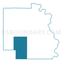
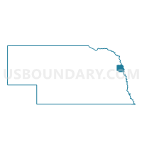
Outline

Summary
| Unique Area Identifier | 612499 |
| Name | Craig Precinct |
| County | Burt County |
| State | Nebraska |
| Area (square miles) | 56.25 |
| Land Area (square miles) | 56.23 |
| Water Area (square miles) | 0.02 |
| % of Land Area | 99.96 |
| % of Water Area | 0.04 |
| Latitude of the Internal Point | 41.76173260 |
| Longtitude of the Internal Point | -96.39463960 |
Maps

Graphs
Select a template below for downloading or customizing gragh for Craig Precinct, Burt County, Nebraska


Neighbors
Neighoring Voting District (by Name) Neighboring Voting District on the Map
- BellCreek-Oakland-Pershing Precinct, Burt County, NE
- Fontanelle Precinct, Washington County, NE
- Herman Precinct, Washington County, NE
- Logan-Hooper Precinct, Dodge County, NE
- Oakland City 1, Burt County, NE
- Silver Creek-Summit Precinct, Burt County, NE
Top 10 Neighboring County Subdivision (by Population) Neighboring County Subdivision on the Map
- Township 5, Washington County, NE (1,294)
- Oakland city, Burt County, NE (1,244)
- Summit township, Burt County, NE (478)
- Craig township, Burt County, NE (460)
- Logan township, Dodge County, NE (433)
- Bell Creek township, Burt County, NE (239)
- Pershing township, Burt County, NE (149)
- Silver Creek township, Burt County, NE (121)
Top 10 Neighboring Place (by Population) Neighboring Place on the Map
Top 10 Neighboring Unified School District (by Population) Neighboring Unified School District on the Map
- Tekamah-Herman Community Schools, NE (3,386)
- Logan View Public Schools, NE (3,110)
- Oakland Craig Public Schools, NE (2,114)
Top 10 Neighboring State Legislative District Upper Chamber (by Population) Neighboring State Legislative District Upper Chamber on the Map
Top 10 Neighboring 111th Congressional District (by Population) Neighboring 111th Congressional District on the Map
Top 10 Neighboring Census Tract (by Population) Neighboring Census Tract on the Map
- Census Tract 9636, Dodge County, NE (5,026)
- Census Tract 503, Washington County, NE (4,435)
- Census Tract 9633, Burt County, NE (2,668)
- Census Tract 9632, Burt County, NE (2,158)